|
|
Randolph Petitions > Events > Smith Trail
Access to Smith Trail
Jan. 2024 Planning Board hearing on Scanlon Drive development, including new access to the Blue Hills
There's a Randolph Planning Board meeting on Jan. 23 which includes constructing a new access point to the Smith Trail in Randolph.
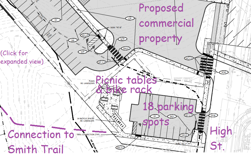
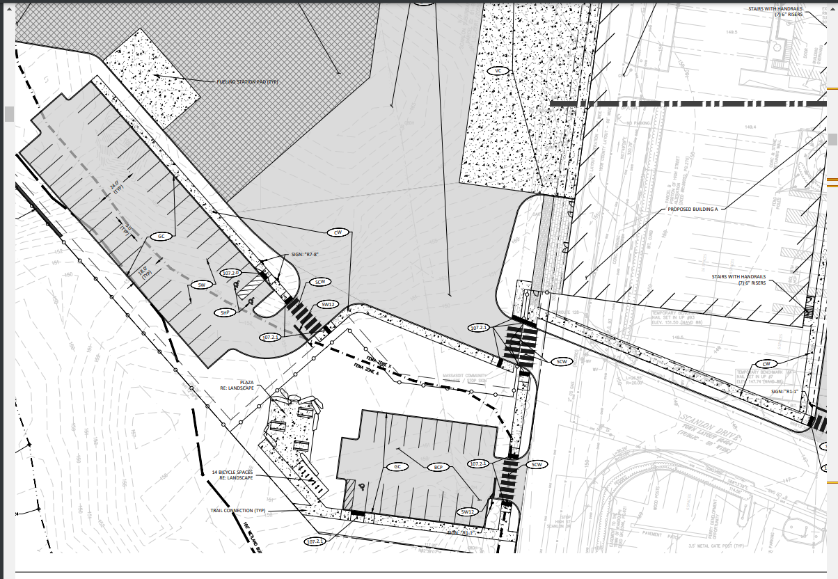
That access point, from Scanlon Drive and High Street, has been physically blocked for many years. The new plans include a trailhead and 18 dedicated parking spots, in the PDF presentation to the Planning Board.
More parking access at Blue Hills trailheads has been a priority of the Friends of the Blue Hills (FBH) for some time now -- FBH featured that topic in a newsletter two years ago. I plan to say "maintaining a trailhead and dedicated parking spots is a priority of the Friends of the Blue Hills" at the Planning Board meeting.
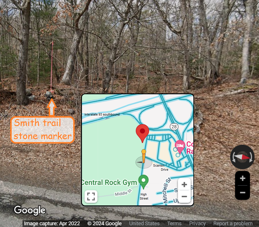
The developer's detailed plans are linked above, with excerpts relevant to Smith Trail below. It's likely you've never heard of Smith Trail -- because it's been blocked for years -- but it's on the DCR Blue Hills map, and there's a DCR "stone marker" somewhere near Scanlon Drive.
The RICC "Mass in Motion" hike in autumn 2023 included part of Smith Trail, accessed by heading north then east from the Donovan School, since hikers cannot get to Smith Trail any other way -- until this construction is done!
p.9/185: "Discussions are taking place with the Conservation Commission regarding storm water, DCR regarding the trailhead parking" = Friends of the Blue Hills (FBH) is not mentioned here, but FBH actually performs the trail maintenance regarding storm water, and all other routine maintenance.
p.9/185: "Applicant intends to go to Town Council to discontinue/abandon Billings Way" = this means there will be another hearing, perhaps in winter or spring 2024, where I will say the same FBH notes again. "Billings Way" is the fictional "street" that is the center aisle of the Lombardo's parking lot. "Abandoning" that street is needed because it's where the developer wants to add a new building (between the highway and the current Lombardo's site). This has nothing to do with the Blue Hills, except that Billings Way has a "dead end" at its western end at the Blue Hills.
p.19/85: "Property C, at the intersection of High Street and Scanlon Drive, is intended to establish an easement to DCR for public use of this parcel as the trailhead and a related parking area. The origin of this concept was developed as a part of a land swap agreement [with] DCR. The initial design was to provide ten (10) dedicated spaces for trailhead parking." = The "land swap" was done many years ago and is the reason that Smith Trail's enrtance got blocked -- because the trailhead was never built -- now it will be!
p. 20/85 "Due to the nature of Maxim's use, the pre-existence of the cell tower, and DCR's need for a trailhead, the western half of the site (Properties A, C and D) came together organically" = "Maxim's" refers to the development proposal to the west of High Street, which includes the proposed new trailhead.
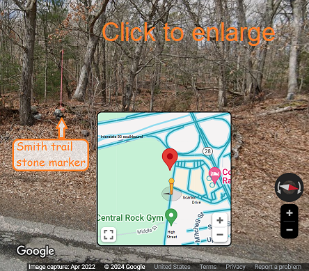 p. 34/185: "Trail Connection" on map" = The trailhead proposal includes a separate entrance just south of Scanlon Drive, with 18 car parking spots and a bicycle rack and picnic tables. There's an abandoned private home on that spot now -- The "Trail Connection" just south of all that. The official Smith Trail entrance is indicated by a "marker stone" (which is at the official trailhead of every DCR trail).
p. 60/185: "The site will also construct a new trailhead and parking lot for the Department of Conservation and Recreation's (DCR's) Blue Hills Reservation near the intersection of High Street and Scanlon Street with approximately 18 parking spaces." = This is the Executive Summary (which means the developers gave it high priority).
p. 97/185, in "Transportation Mitigation" section: "As a means of supporting the extensive existing DCR trails/paths in the area, the project is proposing to construct a trailhead parking area off High Street with approximately 18 parking spaces. Currently there is no way to easily get access to the trails from this area of Randolph, so this improvement will not only create a formal entrance, but also make this nearby amenity more known and visible." = This is what I've been saying for years!
p. 99/185 in "Conclusion and Recommendation" section: "The Project's construction of a DCR trailhead will support more recreational use of park facilities in the area for residents and new employees of the site." = I agree entirely! Please come and support this project!
p. 34/185: "Trail Connection" on map" = The trailhead proposal includes a separate entrance just south of Scanlon Drive, with 18 car parking spots and a bicycle rack and picnic tables. There's an abandoned private home on that spot now -- The "Trail Connection" just south of all that. The official Smith Trail entrance is indicated by a "marker stone" (which is at the official trailhead of every DCR trail).
p. 60/185: "The site will also construct a new trailhead and parking lot for the Department of Conservation and Recreation's (DCR's) Blue Hills Reservation near the intersection of High Street and Scanlon Street with approximately 18 parking spaces." = This is the Executive Summary (which means the developers gave it high priority).
p. 97/185, in "Transportation Mitigation" section: "As a means of supporting the extensive existing DCR trails/paths in the area, the project is proposing to construct a trailhead parking area off High Street with approximately 18 parking spaces. Currently there is no way to easily get access to the trails from this area of Randolph, so this improvement will not only create a formal entrance, but also make this nearby amenity more known and visible." = This is what I've been saying for years!
p. 99/185 in "Conclusion and Recommendation" section: "The Project's construction of a DCR trailhead will support more recreational use of park facilities in the area for residents and new employees of the site." = I agree entirely! Please come and support this project!
|